Embarking on a road trip along the world’s most spectacular routes offers an unparalleled blend of adventure, breathtaking scenery, and unforgettable experiences. From winding mountain passes to coastal highways hugging dramatic shorelines, these iconic roads present both thrilling challenges and awe-inspiring vistas. Whether you’re a seasoned traveller or a first-time explorer, these routes promise to ignite your wanderlust and create lasting memories.
Iconic alpine routes: navigating the stelvio pass and grossglockner high alpine road
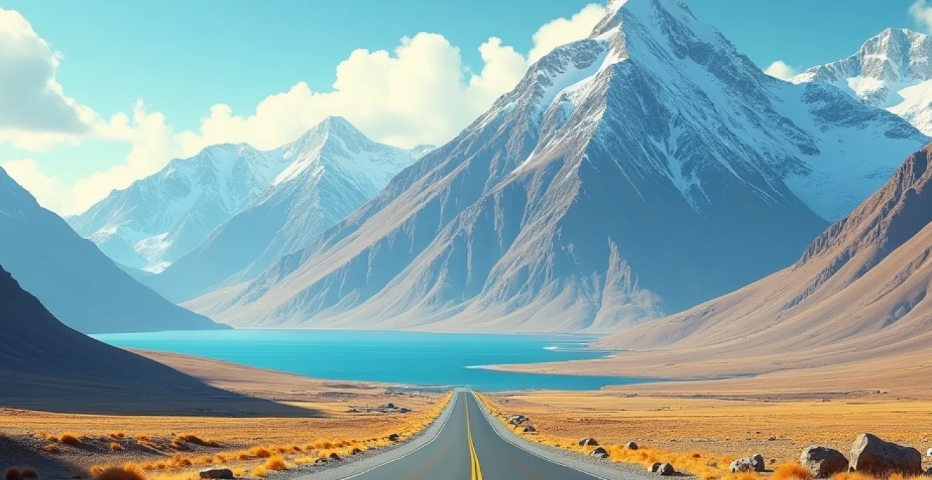
The European Alps boast some of the most exhilarating driving experiences in the world, with the Stelvio Pass and Grossglockner High Alpine Road standing out as true gems for motoring enthusiasts. These routes offer a perfect blend of engineering marvels and natural beauty, challenging drivers while rewarding them with stunning panoramas.
Engineering marvels of the stelvio pass: 48 hairpin turns and 2,757-meter elevation
The Stelvio Pass, located in northern Italy, is renowned for its serpentine path that features an astounding 48 hairpin turns. This engineering feat, completed in 1825, remains a testament to human ingenuity and determination. As you ascend to its peak at 2,757 meters above sea level, you’ll experience a thrilling combination of technical driving and breathtaking Alpine scenery.
Navigating the Stelvio Pass requires utmost concentration and skill. Each hairpin turn presents a new challenge, with steep gradients and narrow roads demanding precise steering and careful throttle control. The reward for this intense driving experience is unparalleled views of the surrounding Ortler Alps, with snow-capped peaks stretching as far as the eye can see.
The Stelvio Pass is not just a road; it’s a pilgrimage for driving enthusiasts and a true test of both driver and machine.
Grossglockner’s panoramic vistas: Kaiser-Franz-Josefs-Höhe viewpoint and pasterze glacier
While the Stelvio Pass offers technical challenges, the Grossglockner High Alpine Road in Austria provides a more leisurely, yet equally spectacular driving experience. This 48-kilometre route winds through the heart of the Hohe Tauern National Park, offering unparalleled views of Austria’s highest peak, the Grossglockner.
The highlight of this journey is undoubtedly the Kaiser-Franz-Josefs-Höhe viewpoint. At an elevation of 2,369 meters, this observation deck provides a stunning panorama of the Pasterze Glacier, Austria’s longest ice stream. The contrast between the rugged alpine terrain and the flowing glacier creates a mesmerising vista that captivates visitors year-round.
As you drive along the Grossglockner High Alpine Road, you’ll encounter a series of educational exhibits and information points. These stops offer fascinating insights into the region’s geology, flora, and fauna, making the journey both thrilling and educational. The road’s smooth surfaces and wider lanes make it more accessible than the Stelvio Pass, allowing drivers to fully appreciate the surrounding beauty.
Seasonal considerations: optimal driving periods and weather challenges
Both the Stelvio Pass and the Grossglockner High Alpine Road are subject to seasonal closures due to harsh winter conditions. Typically, these routes are open from late May to early November, with the optimal driving period being from June to September. During these months, you can expect clearer skies and more stable weather conditions, enhancing both safety and the overall experience.
However, even during the summer months, weather in the Alps can be unpredictable. It’s crucial to check local forecasts and road conditions before setting out. Sudden changes in weather can lead to reduced visibility, wet roads, or even snowfall at higher elevations. Being prepared with appropriate clothing, emergency supplies, and a well-maintained vehicle is essential for a safe and enjoyable journey.
When planning your Alpine road trip, consider visiting during the shoulder seasons of late spring or early autumn. These periods offer a balance between good weather conditions and fewer tourists, allowing for a more serene driving experience. Additionally, the changing colours of Alpine flora during these times add an extra dimension of beauty to your journey.
Coastal splendour: australia’s great ocean road and norway’s atlantic road
Shifting from mountain passes to coastal highways, two routes stand out for their stunning seaside scenery and engineering prowess: Australia’s Great Ocean Road and Norway’s Atlantic Road. These coastal drives offer a stark contrast to the Alpine routes, showcasing the raw power and beauty of the ocean alongside dramatic cliffside vistas.
Limestone stacks of the twelve apostles: geological formation and erosion processes
The Great Ocean Road, stretching 243 kilometres along Australia’s southeastern coast, is renowned for its iconic limestone formations, particularly the Twelve Apostles. These majestic sea stacks, rising dramatically from the Southern Ocean, are the result of millions of years of erosion.
The formation process of the Twelve Apostles began approximately 20 million years ago when the sea level was much lower. As the ocean rose, it gradually eroded the softer limestone, carving out caves in the cliffs. Over time, these caves expanded into arches, which eventually collapsed, leaving the isolated rock stacks we see today.
Driving along the Great Ocean Road offers numerous vantage points to observe these geological wonders. The best views are often at sunrise or sunset when the changing light casts a golden glow on the limestone stacks, creating a truly magical atmosphere. It’s worth noting that despite their name, only eight of the Twelve Apostles remain standing, with the ninth collapsing in 2005, serving as a reminder of the ever-changing nature of this coastline.
Atlantic road’s storseisundet bridge: engineering feat amidst harsh nordic conditions
In stark contrast to the sun-drenched coast of Australia, Norway’s Atlantic Road offers a more dramatic and challenging driving experience. This 8.3-kilometre stretch, part of County Road 64, connects a series of small islands and skerries with a total of eight bridges. The most famous and visually striking of these is the Storseisundet Bridge, often referred to as “The Bridge to Nowhere”.
The Storseisundet Bridge is an engineering marvel, designed to withstand the harsh conditions of the Norwegian Sea. Its distinctive curved design creates an optical illusion as you approach, appearing to end abruptly mid-air. This effect is particularly pronounced in foggy conditions, adding an element of surreal beauty to the drive.
Driving across the Atlantic Road is like navigating through a symphony of waves, wind, and engineering brilliance.
The construction of the Atlantic Road was a monumental task, completed in 1989 after facing 12 hurricanes during the six-year building period. Today, it stands as a testament to human perseverance and ingenuity in the face of nature’s formidable forces. The road’s design allows drivers to experience the full power of the Nordic seas, with waves often crashing over the barriers during stormy weather.
Wildlife encounters: southern right whales and atlantic puffins
Both the Great Ocean Road and the Atlantic Road offer unique opportunities for wildlife encounters. Along the Australian coast, lucky travellers might spot Southern Right Whales between June and September. These majestic creatures migrate to the warmer waters of southern Australia to give birth and nurse their young. Several lookout points along the Great Ocean Road provide excellent vantage points for whale watching.
On the Norwegian side, the Atlantic Road is renowned for its rich birdlife, particularly the charismatic Atlantic Puffins. These colourful seabirds, often called “sea parrots” due to their distinctive beaks, nest on nearby islands during the summer months. The road’s many stopping points offer perfect opportunities for birdwatching and photography, allowing visitors to observe these fascinating creatures in their natural habitat.
In addition to whales and puffins, both routes offer chances to spot a variety of marine life, including dolphins, seals, and numerous seabird species. This abundance of wildlife adds an extra layer of excitement to these coastal drives, turning them into mobile safaris where natural wonders can appear at any moment.
Desert expeditions: route 66 and namibia’s skeleton coast
Venturing into more arid landscapes, we explore two iconic desert routes that offer unique driving experiences: the historic Route 66 in the United States and the remote Skeleton Coast of Namibia. These roads present a stark contrast to the lush Alpine and coastal routes, showcasing the raw beauty of desert landscapes and the challenges they pose to travellers.
Navigating namibia’s Shipwreck-Lined coastline: cape cross seal reserve to terrace bay
Namibia’s Skeleton Coast, stretching along the country’s northern coastline, is one of the most remote and hauntingly beautiful driving routes in the world. This desolate stretch of shoreline, where the Namib Desert meets the Atlantic Ocean, is renowned for its treacherous waters and the numerous shipwrecks that dot its coast.
The journey along the Skeleton Coast typically begins at the Cape Cross Seal Reserve, home to one of the largest Cape fur seal colonies in the world. As you drive north, the landscape becomes increasingly barren, with vast expanses of sand dunes meeting the crashing waves of the Atlantic. The road itself is often little more than a track through the sand, requiring careful navigation and a well-equipped 4×4 vehicle.
One of the most striking features of this drive is the presence of shipwrecks along the coast. These rusting hulks, some dating back centuries, serve as eerie reminders of the area’s dangerous waters and harsh conditions. The most famous of these is perhaps the Eduard Bohlen, a German cargo ship that ran aground in 1909 and now sits several hundred meters inland due to the advancing desert.
As you approach Terrace Bay, the northernmost point accessible to self-drive tourists, the landscape becomes even more surreal. Here, you’ll find yourself surrounded by towering sand dunes on one side and the mist-shrouded Atlantic on the other, creating an otherworldly atmosphere that’s unlike anywhere else on Earth.
Off-road challenges: vehicle preparation for extreme desert conditions
Driving in extreme desert conditions, whether on Route 66 or the Skeleton Coast, requires thorough preparation and a well-equipped vehicle. For the Skeleton Coast, a 4×4 vehicle with high ground clearance is essential. Key preparations include:
- Extra fuel and water reserves
- Emergency communication devices (satellite phone recommended)
- Basic vehicle repair kit and spare tyres
- GPS navigation system and physical maps
- Sun protection and appropriate clothing for extreme temperature changes
For Route 66, while less extreme than the Skeleton Coast, preparation is still crucial. The remote stretches of this historic highway can present challenges, especially in the desert regions of the American Southwest. Ensure your vehicle is in good condition, with particular attention to cooling systems and tyres suitable for hot asphalt.
In both cases, it’s vital to inform others of your travel plans and expected arrival times. The isolation of these routes means that self-reliance is key, and being prepared for unexpected situations can make the difference between a challenging adventure and a potentially dangerous predicament.
Mountain passes of the himalayas: khardung la and zoji la
The Himalayan mountain range offers some of the most challenging and breathtaking driving experiences in the world. Two passes in particular, Khardung La and Zoji La, stand out for their extreme elevation and treacherous conditions. These routes are not for the faint-hearted, but for those who dare, they offer unparalleled views and a true test of driving skill.
Khardung la’s 5,359-meter challenge: acclimatisation strategies and oxygen deprivation
Khardung La, located in the Ladakh region of India, is often claimed to be the world’s highest motorable pass at an elevation of 5,359 meters (17,582 feet). While this claim is disputed, there’s no doubt that driving this pass presents unique challenges due to its extreme altitude.
The most significant challenge faced by drivers on Khardung La is the risk of altitude sickness. At this elevation, the air contains only about half the oxygen found at sea level. Symptoms of altitude sickness can include headaches, dizziness, nausea, and in severe cases, potentially life-threatening conditions such as high-altitude pulmonary edema (HAPE) or cerebral edema (HACE).
To mitigate these risks, proper acclimatisation is crucial. Strategies for acclimatisation include:
- Gradual ascent, spending at least 2-3 days at intermediate altitudes before attempting the pass
- Staying well-hydrated and avoiding alcohol
- Consuming a high-carbohydrate diet to help with oxygen utilisation
- Considering medication such as Acetazolamide (Diamox) under medical advice
- Recognising symptoms early and being prepared to descend if necessary
Despite these challenges, the views from Khardung La are truly spectacular, offering panoramic vistas of the Karakoram range and the Indus Valley below. The sense of achievement upon reaching the pass is unparalleled, making it a bucket-list destination for many adventure seekers.
Zoji la’s treacherous 9-kilometre stretch: navigating mudslides and avalanche zones
While not as high as Khardung La, Zoji La presents its own set of formidable challenges. This 9-kilometre mountain pass connects the Kashmir Valley with Ladakh, traversing the western section of the Himalayan range at an elevation of about 3,528 meters (11,575 feet).
Zoji La is notorious for its narrow, unpaved roads that cling precariously to steep mountainsides. The pass is often shrouded in fog or mist, severely limiting visibility. During the monsoon season, mudslides are a constant threat, while in winter, the risk shifts to avalanches and black ice.
Navigating Zoji La requires extreme caution and experience. Key considerations include:
- Checking weather conditions and road status before attempting the pass
- Using a vehicle with high ground clearance and four-wheel drive
- Driving slowly and being prepared for sudden stops or reversing
- Carrying emergency supplies, including warm clothing and food
- Being aware of symptoms of altitude sickness, even at this lower elevation
Despite its challenges, Zoji La offers stunning views of the surrounding Himalayan peaks and serves as a crucial link between two distinct regions of India. The sense of isolation and raw natural beauty experienced on this pass is truly unforgettable.
Border roads organisation (BRO): maintaining critical High-Altitude infrastructure
The maintenance of these high-altitude passes is a monumental task, primarily undertaken by India’s Border Roads Organisation (BRO). This military engineering organisation plays a crucial role in keeping these vital arteries open, often working in extreme conditions.
The BRO faces numerous challenges in maintaining roads like Khardung La and Zoji La:
- Extreme weather conditions, with temperatures dropping well below freezing
- Short working seasons due to heavy snowfall and monsoon rains
- Logistical difficulties in transporting equipment and materials to high altitudes
- Constant threats from landslides, avalanches, and erosion
- The need for specialised equipment capable of operating at high altitudes
The efforts of the BRO are critical not only for tourism and local transportation but also for national security, as many of these high-altitude roads serve as vital supply routes for military outposts along India’s borders.
Tropical paradise routes: hawaii’s hana highway and costa rica’s nicoya peninsula
Transitioning from the stark landscapes of desert and mountain to lush
tropical paradises, we explore two iconic routes that offer a perfect blend of scenic beauty and cultural immersion: Hawaii’s Hana Highway and Costa Rica’s Nicoya Peninsula. These drives showcase the lush landscapes, pristine beaches, and vibrant ecosystems of tropical destinations, providing a stark contrast to the rugged terrains we’ve explored earlier.
Hana highway’s 620 curves: navigating rainforest microclimates and one-lane bridges
The Hana Highway, a 64-mile stretch of road connecting Kahului to Hana on the island of Maui, is renowned for its stunning beauty and challenging drive. With 620 curves and 59 bridges, many of which are one-lane, this road demands full attention from drivers while rewarding them with breathtaking views at every turn.
As you navigate the Hana Highway, you’ll pass through a variety of microclimates within the rainforest. The road winds through dense tropical vegetation, offering glimpses of cascading waterfalls, serene pools, and dramatic coastlines. The frequent changes in elevation and proximity to the ocean create unique weather patterns, with sunny stretches giving way to misty areas in a matter of minutes.
One of the most challenging aspects of driving the Hana Highway is negotiating the numerous one-lane bridges. These narrow crossings require patience and cooperation among drivers, as well as adherence to local right-of-way customs. It’s essential to approach each bridge slowly and be prepared to yield to oncoming traffic when necessary.
The Hana Highway is not just a road; it’s a journey through the heart of Maui’s tropical paradise, where each curve reveals a new wonder of nature.
To fully appreciate the Hana Highway, it’s recommended to take your time and make frequent stops. Some must-visit points along the route include:
- Twin Falls: An easily accessible waterfall and swimming hole
- Wai’anapanapa State Park: Famous for its black sand beach and freshwater caves
- Hana Lava Tube: An underground lava formation you can explore
- Hamoa Beach: A crescent-shaped beach often described as Maui’s most beautiful
Nicoya peninsula’s biodiversity: transitions from dry tropical forest to mangrove ecosystems
Costa Rica’s Nicoya Peninsula offers a diverse driving experience that showcases the country’s rich biodiversity. This region is known for its blue zone status, where people live exceptionally long lives, attributed in part to the natural environment and lifestyle.
As you drive through the Nicoya Peninsula, you’ll witness dramatic transitions in ecosystems. The journey begins in the dry tropical forests of the interior, characterized by deciduous trees and a distinct dry season. As you approach the coast, the landscape gradually shifts to lush coastal forests and eventually to mangrove ecosystems.
The road network in the Nicoya Peninsula varies from well-paved highways to rugged dirt tracks, offering a mix of comfortable cruising and adventurous off-road experiences. Key routes to explore include:
- Route 160: Connecting major beach towns along the peninsula’s western coast
- Route 21: The main artery running through the peninsula’s interior
- Coastal roads linking smaller communities and hidden beaches
Wildlife enthusiasts will find the Nicoya Peninsula particularly rewarding. Keep an eye out for howler monkeys in the forest canopy, scarlet macaws flying overhead, and if you’re lucky, sea turtles nesting on the beaches during the right season. The peninsula’s waters are also home to diverse marine life, including humpback whales that migrate to the area annually.
Sustainable tourism initiatives: balancing road trip adventures with environmental conservation
As these tropical paradises gain popularity among road trip enthusiasts, there’s a growing emphasis on sustainable tourism practices to preserve their natural beauty and ecological integrity. Both Hawaii and Costa Rica have implemented various initiatives to promote responsible travel and minimize the environmental impact of tourism.
In Hawaii, the Sustainable Tourism Association of Hawaii (STAH) works to educate visitors about eco-friendly practices. When driving the Hana Highway, travelers are encouraged to:
- Stay on designated trails and respect private property
- Use reef-safe sunscreen to protect marine ecosystems
- Support local businesses and artisans along the route
- Participate in beach clean-up activities or volunteer conservation projects
Costa Rica, known for its commitment to environmental conservation, has developed a Certification for Sustainable Tourism (CST) program. When planning your Nicoya Peninsula road trip, consider:
- Choosing eco-lodges and hotels certified by CST
- Opting for electric or hybrid vehicles when available
- Engaging in community-based tourism activities that benefit local populations
- Following Leave No Trace principles when exploring natural areas
By embracing these sustainable practices, road trip enthusiasts can ensure that these tropical paradises remain pristine for future generations to enjoy. As you embark on your journey through the lush landscapes of Hawaii’s Hana Highway or Costa Rica’s Nicoya Peninsula, remember that responsible travel is key to preserving the very beauty that draws us to these remarkable destinations.